Continuing the tale of the amazing March 4th hike along the PR-CV 147 around the Barranco del Infierno a.k.a. "Hell's Ravine". Where did I leave off? Oh yeah! We'd climbed up some of those 6500 ancient steps and spent some time goofing around with the cameras in a daisy-filled field of flowery almond trees! In other words we were pretty much at point 3 on this map:

Now, that would have been a lovely place for lunch... but as you can see we weren't even halfway around the route so decided to continue on until we reached the next spring. As I mentioned in the first half of this tale, once we'd reached the top of the ravine (nice steep climb with lots of steps) I was thinking the hike wasn't nearly as tough as I'd been led to believe, figuring that we'd probably follow a road or path or something up top to get back to the village of Fleix where we'd left the cars... Ummm... NOPE! I hadn't seen that map above (it's a shot from the end of the trek) or I would have known that the route involved climbing in and out of THREE RAVINES! So that's how they made it to 6500 steps... OUCH! And here's a pretty good view of the next two (right before we start climbing down the 2nd).

We need to cross to the crest right in front of us, and then the base of that mountain in the background... Down and up and down and up. Oh boy! Deep breath, and down we go! ;o)

About halfway down we stopped for lunch in the shade by the Font de Reinós (blue water drop on that map),

and then continued on down to the base of our second ravine, which was still part of the riverbed for the Girona River, albeit about 110m higher up than our previous crossing point.

That height difference is over a very short distance in the actual Barranco del Infierno, the place you need technical expertise (and ropes etc.) to access. You can actually see the entrance to the Barranco in this next shot, taken about halfway up the other side of the ravine:
 |
| entrance to the Barranco del Infierno |
Would have been nice to walk along the riverbed to see what the beginning of the Barranco looks like, but we didn't have much time to spare after our earlier detour to the Isbert Dam and the almond tree photo session... guess I'll just have to go back! ;o)
One of the things I found really interesting climbing in and out of these ravines, was looking back at the other face and seeing the trail we'd taken down to the riverbed! (plus it gave me a good excuse to stop and catch my breath during the climb).
 |
| path down from the Juvea d'Enmig |
I mentioned in the first half of this tale that these paths with the 6500 steps were built by the Arabs between 500-1000 years ago (can't find dates), so they could access the terraces they'd laid out for agriculture (sadly most are abandoned now, labour is too expensive). This shot should help you see what an impressive piece of engineering this was:

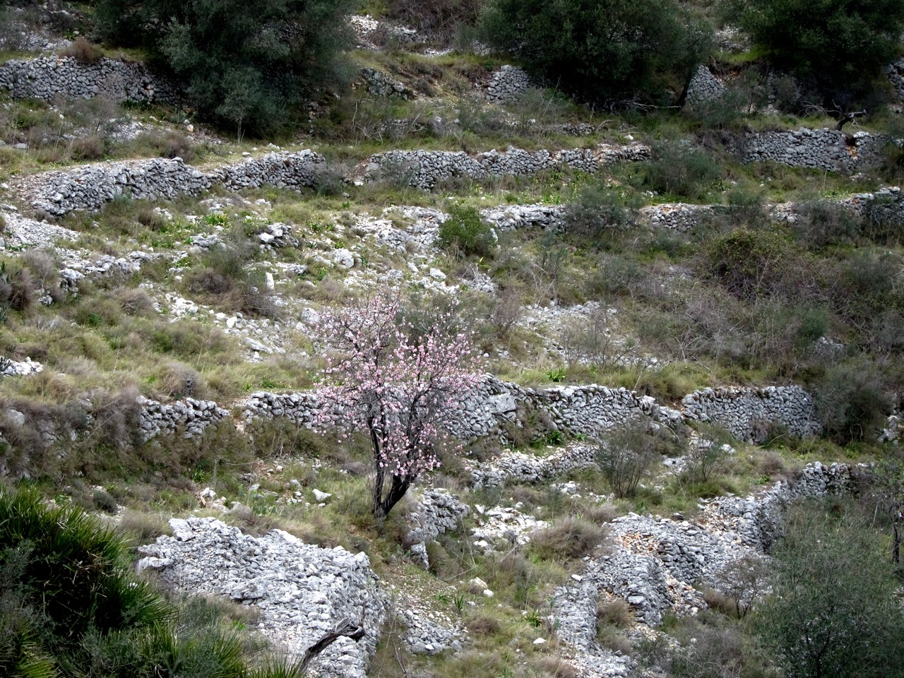 |
| lonely almond tree in centuries-old terraces |
Up top, at Juvea de Dalt (point 5 on the map), plenty of old abandoned masías (farmhouses) and some breathtaking views:
 |
| Old covered well by an abandoned house |
Oh, and almonds weren't the only things grown on those terraces... would anyone care for an onion? :D

Not much dilly-dallying anymore, as it was half past four and we still had one more ravine to cross in order to get up there (to the level area just below the crest):

So down we go, along a much better preserved set of steps than the second ravine (I wasn't 100% there were steps in that one!).

Occasionally stopping to just take in the scenery...
 |
| looking down the Barranco del Tuerto |
And admiring the vegetation down in the third ravine (map point 6, the Barranco del Tuerto or "One-Eyed Man's Ravine"), like this Euphorbia:

I got distracted by that Euphorbia (had trouble getting a decent macro shot), and before I knew it the others were quite a bit higher up on the trail!

So I hurried to catch up with them, all the while watching my step to avoid falling through places where part of the path had been washed away like here:

I caught up with them at this rocky outcropping which offered a stunning view:
 |
| Feel like I'm at the "top of the world"! |
I got a panoramic shot, but because of the panoramic settings and the stitching process the colours don't come out as well... but it's still... wow!
 |
| Barranco del Tuerto (part of the PR-CV-147) |
No one seems to have made note of the fact that the three ladies in the group just happen to be a blond, a brunette and a redhead!... Well we did, and totally had to set up this shot for laughs:
 |
| Charlie's Angels! ;o) |
Half past five, the light is going away, clouds are starting to cover the sky... thankfully this is our final climb!

So let's take a moment to look down and admire the ingenuity of the engineers of old...

and then breathe a sigh of relief that we've survived the 6500 steps into (and out of) Hell and enjoy the view from the top! ;o)
 |
| looking down towards the Mediterranean at the Montgó (centre) and the Cavall Verd (right) |
Here we're checking out the map you have at the beginning of this post (now at point 7),


and my legs are kind of shaking just thinking of the vertical profile of the hike. A total climb of 750m (2460ft). The longest (and hardest) part was that first climb, because although the third climb was steeper, the path meandered a lot more along the side of the ravine so it was easier on the legs (or would have been if they weren't already exhausted from the rest of the hike!).
Up top we were back in almond country, and could take note of the fact that the bloom season was almost over as most of the trees had leaves instead of flowers...

 |
| final almond blossoms? |
This is also cherry country! But sadly seeing the state of these trees we were still a good 2-3 weeks early and would have to come back if we wanted to see cherry blossoms...

But lucky us! As we were hiking back down towards the villages, we came across this field with a gorgeous blooming cherry tree:

Extra luck: the end-of-day light was perfect to get some pretty good photos! ;o)


Just a few shots, then it was continuing on down the road through the town of Benimaurell (map point 8) with its own nicely conserved lavadero:


And then 15' later we were approaching Fleix, almost 8h - and ~15km - after we'd started out (map point 1, where the cars were parked):
 |
| coming upon Fleix |
I'm going to end this where I started, by looking out over the Barranco del Infierno and simply taking in the wonder of those "stairs" climbing up the other side...
 | |
| start/finish of the PR-CV-147 around the Barranco del Infierno |
AWESOME hike! You got some gorgeous photos and I really loved the one of you "On top of the world!" Isn't that an amazing feeling to be at the top of a peak like that and looking out at the horizon? Another winning post!
ReplyDeleteI LOVE that "top of the world" feeling! :o)
DeleteI LOVE the Charlie's Angels shot!
ReplyDeleteThat was SO much fun! We just couldn't resist doing it once it dawned on me that we had just the right colour-combo! :p
Delete